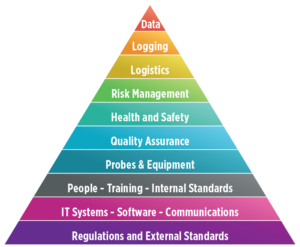
Borehole services for geophysical surveys or geotechnical surveys requires many systems to support field operations and the delivery of the highest quality data.
The model shown here usefully describes some of the components necessary for successful borehole logging.
Data
Borehole logging for geophysical investigations and geotechnical site investigations is essentially about the delivery of high quality calibrated subsurface data.
For most boreholes, a variety of probes are deployed, the data from which are QC checked in real time in the field. Data is then ready for processing, usually back at base but sometimes in the field, typically for offshore geotechnical surveys. In all cases, the processed data will then go through a final QC check by the Data Solutions Team to ensure that it conforms, meets client requirements and is consistent with any earlier submissions. Normally data turnaround time is within 24 hours.
Larger, more complex geophysical surveys or geotechnical surveys will require a comprehensive final report. The RGS engineers will prepare this and it will comprise a factual report and a fully consistent set of data in appropriate formats.
For client peace of mind and for our own internal QC analyses, RGS will maintain a copy of all borehole logging data in our database in perpetuity.
Logging
By deploying only two man crews for all borehole services (initially as a result of risk assessment) RGS have increased the efficiency of operations to the point where customer satisfaction responses are almost all positive. Simple things like arriving on time, at the right place, with all necessary equipment and spares and working long hours have served to mostly eliminate client downtime attributable to RGS.
RGS engineers are all experienced and fully trained and have the ability to solve problems on site and in the unlikely event that external support is needed this is only a mobile phone call away.
All data collected is always QC checked both during logging and by replay at the end of the log to ensure integrity. This is vital if the borehole is to be filled in immediately following logging, common practice for geotechnical site investigations.
Offshore geotechnical site investigations are generally conducted by a single engineer. This is due to the time between logging operations or from pressure on berth availability on the vessel.
Logistics
Due to the nature of borehole logging, whereby logging often starts as soon as possible after drilling finishes, it is necessary to be able to respond to client needs at short notice. While planning in advance is necessary, all plans are subject to last minute changes in the fast moving world of geophysical surveys.
For land-based geophysical surveys or geotechnical surveys the ability to deploy a variety of vehicles and systems to cope with the expected terrain is vital. 4WD vehicles and larger 2WD vehicles can be deployed, depending upon site conditions. For locations inaccessible to vehicles portable equipment or marine equipment can be deployed.
For offshore geotechnical surveys, typically on windfarms, it may be necessary to ship the equipment separately from the engineer. RGS can rely on the expertise of our shipping department who have extensive experience arranging shipments to over 140 countries. Wherever possible, in Europe for example, it is common RGS practice to deliver the equipment and engineer directly to the port of departure precisely when needed.
Risk Management
For all borehole logging jobs, a specific set of RAMS (risk and method statements) is prepared and sent to the client prior to mobilisation. An on-site point of work risk assessment (POWRA) is also conducted to account for further specific local risks. Engineers also undertake inductions at all sites so that site specific hazards can be explained and site rules are understood.
Wherever possible, risks are eliminated at source and when this is not possible control measures are put in place such as additional training or PPE or by a revision to procedures. Risk assessments are in place for head office operations and for the storage, operation and transport of radioactive sources.
Geotechnical site investigations may be conducted on active construction sites where risks associated with other operations need to be considered. Geophysical investigations for mining and mineral applications may be conducted in operational mines and quarries, again where other potentially hazardous activities are taking place concurrently.
Health and Safety
Constant attention to all health and safety matters is needed to ensure that staff work safely while performing borehole logging services. Robertson Geo have their own customised health and safety system which is regularly updated and checked by external auditors. This provides a framework for a modern, inclusive system allowing for feedback and remedial action where needed and which meets the requirements of all applicable standards such as the Health and Safety at Work Act 1974.
Training records are kept up to date for each engineer and refresher training is provided at designated routine intervals covering more than twenty specific safety topics. Staff health is continually monitored by providing regular medicals. All engineers carry radiation dosimeters as part of a controlled radiation management programme.
PPE requirements also constantly change over time and the latest equipment is provided for all staff.
Quality Assurance
Robertson Geo is an accredited ISO9001:2015 company, providing assurance for clients engaging in geotechnical surveys or geophysical surveys. All business processes are documented, from customer enquiry through contractual agreement, planning and execution to data delivery and billing. Internal and external audits ensure that systems are adhered to and processes are updated where necessary.
All data collected from Robertson Geo probes used as part of borehole services is quality assured by a comprehensive four tier validation system, comprising precision (repeatability), accuracy (calibration), conformance (borehole test) and real-world support. In addition to a conformance guarantee a unique system for full life cycle history for each probe is maintained which includes an audit trail for all data collected, probe/job allocations, maintenance history and calibration dates.
Probes and Equipment
Robertson Geo manufactures almost all the geophysical equipment that RGS uses which allows for an unparalleled level of backup for the provision of borehole services. This backup includes spare probes, the ability to call off additional equipment from stock and a fast track for repairs. This facility has been key for RGS to almost eliminate down time for clients due to borehole logging equipment problems.
A modern fleet of customised logging vehicles including transit style and 4x4 vehicles, together with portable and offshore configurations means that RGS can log borehole depths to 2000m in almost any environment, for geotechnical site investigations or geophysical investigations.
People, Training and Internal Standards
Borehole logging often requires engineers to work long hours in difficult field conditions with a high level of responsibility. Staff recruitment takes account of this, whereby engineers are selected for technical prowess, willingness to learn, hands-on and communication skills and the ability to work well in a team.
In-house training is provided in relation to geophysical principles, specific probes, equipment use and maintenance plus the software necessary to run the systems and process the data. External training is a continuous process that covers such diverse areas as offshore safety, workplace safety, driving, radiation safety and first aid.
Internal standards have been drawn up and are maintained, as requirements change, to present clients with a consistency of deliverables.
IT Systems, Software and Communications
To successfully control a multifaceted borehole logging operation there is a corresponding need for sophisticated IT systems. Multiple platforms, cloud-based services and remote working capability all put demands on bandwidth in the office, at home and in the field. The software needed to make this all run efficiently is provided not only from company wide distributed systems like Office 365 and SAP Business One, but also from in-house developed software.
For geotechnical surveys and geophysical surveys, the volume of geophysical data and their associated presentations keeps increasing and careful IT discipline is needed to keep everything organised and backed up. Robertson Geo has developed in-house technical software for data acquisition and processing such as GeoCAD®.
The advent of smart phones has been a boon to the borehole logging industry allowing peer to peer communications in most locations. These devices now form an integral part of how data is transferred quickly from the field.
Regulations and External Standards
Over the past 15 years RGS have seen an ever increasing adoption of the regulations and standards that apply to the conduct of borehole logging operations. As designers, developers and manufacturers of all its own equipment Robertson Geo continues to meet similarly stringent standards to compete in the worldwide marketplace.
RGS work in accordance with many standards including “D5753 – 18 Standard Guide for Planning and Conducting Geotechnical Borehole Geophysical Logging” from ASTM International and “BS 5930:2015+A1:2020 Code of practice for ground investigations” from The British Standards Institution. These standards offer specific guidance for the practice of geophysical logging in a geotechnical survey environment.
The adoption of standards streamlines borehole logging contractual arrangements by providing a basis for the methods, equipment and deliverables from geotechnical surveys and geophysical surveys. Robertson Geo have recently contributed to the UK Specification for Ground Investigation 3rd Edition from ICE Publishing. A paper has been submitted entitled “Towards the development of a standard for the PS suspension logger” for the ISC’7 Conference in Barcelona which is a call for a standard to be developed for the PS Logger®.
References
D5753 – 18 Standard Guide for Planning and Conducting Geotechnical Borehole Geophysical Logging ©ASTM International
UK Specification for Ground Investigation 3rd Edition ©ICE Publishing
BS 5930:2015+A1:2020 Code of practice for ground investigations ©The British Standards Institution 2020
Office 365 is a registered Trademark of Microsoft Corporation
SAP Business One is a registered Trademark of SAP America, Inc